


-
[NM#]: 74
[Monument name]: Grangefertagh
[Description]: Round Tower & Church
[Image]:
[Townland]: Grangefertagh
[Location]: 52°46′42″N 7°32′41″W / 52.77841°N 7.544691°W / 52.77841; -7.544691
(National Monuments) -
[NM#]: 78
[Monument name]: Ullard Church
[Description]: Church
[Image]:
[Townland]: Ullard
[Location]: 52°34′49″N 6°55′59″W / 52.580162°N 6.932934°W / 52.580162; -6.932934
(National Monuments) -
[NM#]: 331, 344
[Monument name]: St. John's Abbey, Kilkenny
[Description]: Priory (Augustinian) (part of & chancel)
[Image]: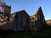
[Townland]: GardensKilkenny City
[Location]: 52°39′13″N 7°14′54″W / 52.653549°N 7.248406°W / 52.653549; -7.248406
(National Monuments) -
[NM#]: 282
[Monument name]: Ballylarkin Church
[Description]: Church
[Image]:
[Townland]: Ballylarkin Upper
[Location]: 52°43′22″N 7°25′39″W / 52.722866°N 7.427629°W / 52.722866; -7.427629
(National Monuments) -
[NM#]: 372
[Monument name]: Callan Motte
[Description]: Motte
[Image]:
[Townland]: Westcourt Demesne
[Location]: 52°32′48″N 7°23′29″W / 52.546749°N 7.391368°W / 52.546749; -7.391368
(National Monuments) -
[NM#]: 620
[Monument name]: Graiguenamanagh Abbey
[Description]: Abbey (Cistercians)
[Image]:
[Townland]: Graiguenamanagh
[Location]: 52°32′27″N 6°57′16″W / 52.54076°N 6.954525°W / 52.54076; -6.954525
(National Monuments)
New Random Display Display All Items(32)