


-
[Name]: Mount Sinai School
[Image]: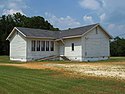
[Dates]:
[Location]:
[City, State]: Autauga County, Alabama
[Description]: -
[Name]: New Hope Rosenwald School
[Image]: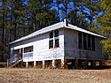
[Dates]: 1915 built2001 NRHP-listed
[Location]: 32°56′36″N 85°17′8″W / 32.94333°N 85.28556°W / 32.94333; -85.28556 (New Hope Rosenwald School)
[City, State]: Fredonia, Alabama
[Description]: -
[Name]: Tankersley Rosenwald School
[Image]: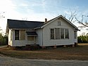
[Dates]: 1922 built2009 NRHP-listed
[Location]:
[City, State]: Hope Hull, Alabama
[Description]:
-
[Name]: Merritt Rosenwald School
[Image]:
[Dates]:
[Location]:
[City, State]: Midway, Alabama
[Description]: -
[Name]: Shiloh Missionary Baptist Church and Rosenwald School
[Image]:
[Dates]:
[Location]:
[City, State]: Notasulga, Alabama
[Description]: -
[Name]: Oak Grove School
[Image]: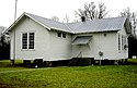
[Dates]: 1925 built1998 NRHP-listed
[Location]: 32°32′48″N 87°40′48″W / 32.54667°N 87.68000°W / 32.54667; -87.68000 (Oak Grove School)
[City, State]: Near Prairieville, Alabama
[Description]: -
[Name]: Rosenwald School (Delight, Arkansas)
[Image]:
[Dates]: 1938 built1990 NRHP-listed
[Location]: 34°2′13″N 93°27′17″W / 34.03694°N 93.45472°W / 34.03694; -93.45472 (Rosenwald School (Delight, Arkansas))
[City, State]: near Delight, Arkansas
[Description]: -
[Name]: Malvern Rosenwald School
[Image]:
[Dates]:
[Location]: 836 Acme St.34°21′45″N 92°49′18″W / 34.36250°N 92.82167°W / 34.36250; -92.82167 (Malvern Rosenwald School)
[City, State]: Malvern, Arkansas
[Description]: NRHP-listed -
[Name]: Mt. Olive Rosenwald School
[Image]:
[Dates]: 1927 built2004 NRHP-listed
[Location]: Bradley Rd. 4533°25′41″N 92°3′33″W / 33.42806°N 92.05917°W / 33.42806; -92.05917 (Mt. Olive Rosenwald School)
[City, State]: Mount Olive, Bradley County, Arkansas
[Description]: Includes Colonial Revival architecture -
[Name]: Oak Grove Rosenwald School
[Image]:
[Dates]:
[Location]:
[City, State]: Oak Grove, Arkansas
[Description]: NRHP-listed -
[Name]: Selma Rosenwald School
[Image]:
[Dates]:
[Location]:
[City, State]: Selma, Arkansas
[Description]: NRHP-listed -
[Name]: Bigelow Rosenwald School
[Image]:
[Dates]: 1926 built2004 NRHP-listed
[Location]: Jct. of AR 60 and Bethel AME Rd.35°4′30″N 92°33′55″W / 35.07500°N 92.56528°W / 35.07500; -92.56528 (Bigelow Rosenwald School)
[City, State]: Toad Suck, Arkansas
[Description]: -
[Name]: Milner-Rosenwald Academy
[Image]:
[Dates]:
[Location]:
[City, State]: Mount Dora, Florida
[Description]: -
[Name]: The Rosenwald School
[Image]:
[Dates]:
[Location]: 624 Bay Street (now Avenue)
[City, State]: Panama City, Florida
[Description]: Building stands but is not in use as a school. See http://www.visitflorida.com/en-us/articles/2008/july/944-the-rosenwald-school-of-panama-city.html. No relation to current Rosenwald High School. -
[Name]: Cusseta Industrial High School
[Image]: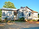
[Dates]:
[Location]:
[City, State]: Cusseta, Georgia
[Description]: -
[Name]: Cedar Grove Rosenwald School
[Image]:
[Dates]:
[Location]:
[City, State]: Olmstead, Kentucky
[Description]: NRHP-listed -
[Name]: Rosenwald High School
[Image]:
[Dates]:
[Location]:
[City, State]: New Roads, Louisiana
[Description]: -
[Name]: Community Rosenwald School
[Image]:
[Dates]:
[Location]:
[City, State]: Grand Cane, Louisiana
[Description]: NRHP-listed -
[Name]: Longstreet Rosenwald School
[Image]:
[Dates]:
[Location]:
[City, State]: Longstreet, Louisiana
[Description]: NRHP-listed -
[Name]: Ridgeley School (officially Colored School No. 1 of Prince George's County)
[Image]:
[Dates]: 1927 built
[Location]: 8507 Central Avenue
[City, State]: Capitol Heights, Maryland
[Description]: Now a museum. -
[Name]: Queenstown Rosenwald School
[Image]: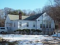
[Dates]: 1932 built2009 NRHP-listed
[Location]: 430 Queenstown Rd.39°8′41.65″N 76°39′8.5″W / 39.1449028°N 76.652361°W / 39.1449028; -76.652361 (Queenstown Rosenwald School)
[City, State]: Severn, Maryland
[Description]: -
[Name]: Lula G. Scott Community Center
[Image]:
[Dates]: 1921 built2009 NRHP-listed
[Location]: 6243 Shady Side Rd.39°50′8.07″N 76°30′48.81″W / 39.8355750°N 76.5135583°W / 39.8355750; -76.5135583 (Lula G. Scott Community Center)
[City, State]: Shady Side, Maryland
[Description]: -
[Name]: San Domingo School
[Image]:
[Dates]: 1919 built2007 NRHP-listed
[Location]: 11526 Old School Rd.38°30′39″N 75°43′22″W / 38.51083°N 75.72278°W / 38.51083; -75.72278 (San Domingo School)
[City, State]: Sharptown, Maryland
[Description]: -
[Name]: Freetown Rosenwald School
[Image]:
[Dates]: 1924 built2007 NRHP-listed
[Location]: 7825 Freetown Rd.39°8′27″N 76°34′38″W / 39.14083°N 76.57722°W / 39.14083; -76.57722 (Freetown Rosenwald School)
[City, State]: Glen Burnie, Maryland
[Description]: -
[Name]: Norbeck School
[Image]:
[Dates]: 1927
[Location]:
[City, State]: Montgomery County, Maryland
[Description]: Locally designated historic site on Montgomery County's Master Plan for Historic Preservation -
[Name]: Highland Park School
[Image]:
[Dates]:
[Location]:
[City, State]: Prince George's County, Maryland
[Description]: had been in continuous use by the school system. It was recently renovated for use as a Headstart Center. -
[Name]: San Domingo Community and Cultural Center (SDCCC)
[Image]:
[Dates]: 1919
[Location]: 11526 Old School Road
[City, State]: Mardela Springs, Maryland
[Description]: Rosenwald School built in 1919, restored during 2004-2014, SDCCC Dedication Ceremony: 8/23/14. NRHP listed. Two-story, three-teacher, Sharptown Colored (Elementary) School. 1919-1957. Sold to community of San Domingo for $10.00. Continuously used as Masonic Lodge meeting hall, daycare center, tutorial center, youth workshops and meeting place for various groups. -
[Name]: Marley Neck Rosenwald School
[Image]: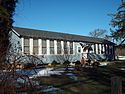
[Dates]:
[Location]:
[City, State]: Anne Arundel County, Maryland
[Description]: -
[Name]: J.W. Randolph School
[Image]:
[Dates]: 1928
[Location]:
[City, State]: Pass Christian, Mississippi
[Description]: -
[Name]: Central School
[Image]:
[Dates]: 1926
[Location]: 414 Watkins St.35°42′38″N 79°48′14″W / 35.71056°N 79.80389°W / 35.71056; -79.80389 (Central School)
[City, State]: Asheboro, North Carolina
[Description]: listed on the National Register of Historic Places in 1993 -
[Name]: Morgan School
[Image]:
[Dates]: 1925-1926
[Location]: 7427 Winters Rd.35°49′18″N 78°8′14″W / 35.82167°N 78.13722°W / 35.82167; -78.13722 (Morgan School)
[City, State]: Bailey, North Carolina
[Description]: listed on the National Register of Historic Places in 2006 -
[Name]: Ware Creek School
[Image]:
[Dates]: 1921
[Location]: East side of NC 1103, .3 miles southeast of junction with NC 111235°25′12″N 76°56′19″W / 35.42000°N 76.93861°W / 35.42000; -76.93861 (Ware Creek School)
[City, State]: Blounts Creek, North Carolina
[Description]: listed on the National Register of Historic Places in 1996 -
[Name]: Billingsville School
[Image]:
[Dates]: 1927
[Location]: 3100 Leroy St.35°11′46″N 80°48′30″W / 35.19611°N 80.80833°W / 35.19611; -80.80833 (Billingsville School)
[City, State]: Charlotte, North Carolina
[Description]: listed on the National Register of Historic Places in 1999 -
[Name]: Siloam School
[Image]:
[Dates]: 1920
[Location]: W side of Mallard Highlands Dr, Approx. 0.25 mi. S from jct. of John Adams Rd.,35°20′10″N 80°44′20″W / 35.33611°N 80.73889°W / 35.33611; -80.73889 (Siloam School)
[City, State]: Charlotte, North Carolina
[Description]: listed on the National Register of Historic Places in 2007 -
[Name]: Coinjock Colored School
[Image]:
[Dates]: 1920
[Location]: 4358 Caratoke Hwy.36°21′46″N 78°36′04″W / 36.36278°N 78.60111°W / 36.36278; -78.60111 (Coinjock Colored School)
[City, State]: Coinjock, North Carolina
[Description]: listed on the National Register of Historic Places in 2013 -
[Name]: Harnett County Training School
[Image]:
[Dates]: 1922-1956
[Location]: 610 E. Johnson St. 35°18′40″N 75°58′00″W / 35.31111°N 75.96667°W / 35.31111; -75.96667 (Harnett County Training School)
[City, State]: Dunn, North Carolina
[Description]: listed on the National Register of Historic Places in 2014 -
[Name]: Russell School (Durham, North Carolina)
[Image]:
[Dates]: 1926-1927
[Location]: 2001 St. Mary's Rd.36°7′24″N 78°56′45″W / 36.12333°N 78.94583°W / 36.12333; -78.94583 (Russell School)
[City, State]: near Durham, North Carolina
[Description]: listed on the National Register of Historic Places in 2009 -
[Name]: Liberty Hill School (Ellerbe, North Carolina)
[Image]:
[Dates]: 1930
[Location]: 234 Covington Comm. Rd.35°08′15″N 79°52′00″W / 35.13750°N 79.86667°W / 35.13750; -79.86667 (Liberty Hill School)
[City, State]: near Ellerbe, North Carolina
[Description]: listed on the National Register of Historic Places in 2008 -
[Name]: Reid's Grove School
[Image]:
[Dates]: 1927
[Location]: 931 Main St.36°25′04″N 78°45′29″W / 36.41778°N 78.75806°W / 36.41778; -78.75806 (Reid's Grove School)
[City, State]: near Gatesville, North Carolina
[Description]: listed on the National Register of Historic Places in 2011 -
[Name]: Zachariah School
[Image]:
[Dates]: 1920
[Location]: NC 1239, 0.6 miles South of NC 124435°31′28″N 77°41′53″W / 35.52444°N 77.69806°W / 35.52444; -77.69806 (Zachariah School)
[City, State]: Greene County, North Carolina
[Description]: listed on the National Register of Historic Places in 2005 -
[Name]: Lincoln Park School
[Image]:
[Dates]: 1922
[Location]: 1272 S. Currant St.35°5′6″N 78°28′25″W / 35.08500°N 78.47361°W / 35.08500; -78.47361 (Lincoln Park School)
[City, State]: Pinebluff, North Carolina
[Description]: listed on the National Register of Historic Places in 1997 -
[Name]: Princeton Graded School
[Image]:
[Dates]: 1925-1926
[Location]: 601-611 W. Edwards St.35°28′11″N 78°10′07″W / 35.46972°N 78.16861°W / 35.46972; -78.16861 (Princeton Graded School)
[City, State]: Princeton, North Carolina
[Description]: listed on the National Register of Historic Places in 2005 -
[Name]: Panther Branch School
[Image]:
[Dates]: 1926
[Location]: NC 2727, 0.5 miles (0.80 km) south of NC 18335°37′59″N 78°38′28″W / 35.63306°N 78.64111°W / 35.63306; -78.64111 (Panther Branch School)
[City, State]: near Raleigh, North Carolina
[Description]: listed on the National Register of Historic Places in 2001 -
[Name]: St. Matthews School (Raleigh, North Carolina)
[Image]:
[Dates]: 1922
[Location]: US 401, 0.5 miles (0.80 km) northeast of NC 221335°51′37″N 78°33′41″W / 35.86028°N 78.56139°W / 35.86028; -78.56139 (St. Matthews School)
[City, State]: near Raleigh, North Carolina
[Description]: listed on the National Register of Historic Places in 2001 -
[Name]: J.C. Price High School
[Image]:
[Dates]: 1931-1932
[Location]: 1300-1400 W. Bank St.35°40′37″N 80°29′07″W / 35.67694°N 80.48528°W / 35.67694; -80.48528 (J.C. Price High School)
[City, State]: Salisbury, North Carolina
[Description]: listed on the National Register of Historic Places in 2010 -
[Name]: Snow Hill Colored High School
[Image]:
[Dates]: 1925
[Location]: 602A W. Harper St.35°26′58″N 77°20′52″W / 35.44944°N 77.34778°W / 35.44944; -77.34778 (Snow Hill Colored High School)
[City, State]: Snow Hill, North Carolina
[Description]: listed on the National Register of Historic Places in 2003 -
[Name]: Walnut Cove Colored School
[Image]: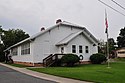
[Dates]: 1921
[Location]: Jct. of Brook and Dalton Sts., NW corner36°18′12″N 80°08′39″W / 36.30333°N 80.14417°W / 36.30333; -80.14417 (Walnut Cove Colored School)
[City, State]: Walnut Cove, North Carolina
[Description]: listed on the National Register of Historic Places in 1995; won a National Preservation Honor Award for its rehabilitation for use as a senior citizens' community center. -
[Name]: W. E. B. DuBois School
[Image]:
[Dates]: 1926
[Location]: 536 Franklin St.35°59′06″N 78°30′04″W / 35.98500°N 78.50111°W / 35.98500; -78.50111 (W. E. B. DuBois School)
[City, State]: Wake Forest, North Carolina
[Description]: listed on the National Register of Historic Places in 1993. -
[Name]: Liberia School
[Image]:
[Dates]: 1921-1922
[Location]: 4.5 miles S of Warrenton, Sw side of NC 5836°21′42″N 78°06′03″W / 36.36167°N 78.10083°W / 36.36167; -78.10083 (Liberia School)
[City, State]: Warrenton, North Carolina
[Description]: listed on the National Register of Historic Places in 2005. -
[Name]: Riley Hill School
[Image]:
[Dates]: 1928
[Location]: NC 2320, 0.2 miles (0.32 km) east of NC 231835°51′34″N 78°24′59″W / 35.85944°N 78.41639°W / 35.85944; -78.41639 (Riley Hill School)
[City, State]: Wendell, North Carolina
[Description]: listed on the National Register of Historic Places in 2001. -
[Name]: Williamston Colored School
[Image]:
[Dates]: 1930-1931
[Location]: 705 Washington St.35°50′45″N 77°03′38″W / 35.84583°N 77.06056°W / 35.84583; -77.06056 (Williamston Colored School)
[City, State]: Williamston, North Carolina
[Description]: listed on the National Register of Historic Places in 2014 -
[Name]: Atkins High School
[Image]:
[Dates]: 1931
[Location]: 1215 N. Cameron Ave.36°06′39″N 80°13′17″W / 36.11083°N 80.22139°W / 36.11083; -80.22139 (Atkins High School)
[City, State]: Winston-Salem, North Carolina
[Description]: listed on the National Register of Historic Places in 1999 -
[Name]: Warren County Training School
[Image]:
[Dates]: 1931
[Location]: East side of NC 1300, 0.8 N of NC 137236°30′56″N 78°09′59″W / 36.51556°N 78.16639°W / 36.51556; -78.16639 (Warren County Training School)
[City, State]: Wise, North Carolina
[Description]: listed on the National Register of Historic Places in 2006. -
[Name]: Arbeka Rosenwald School
[Image]:
[Dates]:
[Location]:
[City, State]: Arbeka, Oklahoma
[Description]: -
[Name]: Douglass School
[Image]: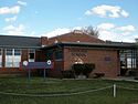
[Dates]:
[Location]:
[City, State]: Lawton, Oklahoma
[Description]: -
[Name]: Rosenwald Hall
[Image]:
[Dates]:
[Location]:
[City, State]: Lima, Oklahoma
[Description]: -
[Name]: Kiowa County Sep. #1
[Image]:
[Dates]:
[Location]:
[City, State]: Hobart, Oklahoma
[Description]: -
[Name]: Lincoln Grade School
[Image]: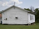
[Dates]:
[Location]:
[City, State]: Lehigh, Oklahoma
[Description]: -
[Name]: Pleasant Hill School
[Image]:
[Dates]:
[Location]:
[City, State]: McCurtain County, Oklahoma
[Description]: -
[Name]: Union School
[Image]:
[Dates]:
[Location]:
[City, State]: Stella, Oklahoma
[Description]: -
[Name]: Great Branch Teacherage
[Image]:
[Dates]: 1924-1925 built2007 NRHP-listed
[Location]:
[City, State]: Orangeburg, South Carolina
[Description]: NRHP-listed -
[Name]: Hannah Rosenwald School
[Image]: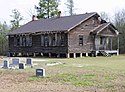
[Dates]: 1924 built2009 NRHP-listed
[Location]: 2890 Neeses Highway
[City, State]: Newberry, South Carolina
[Description]: NRHP-listed -
[Name]: Hope Rosenwald School
[Image]: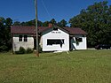
[Dates]: 1925-26 built2007 NRHP-listed
[Location]: 1971 Hope Station Rd.34°16′14″N 81°21′52″W / 34.27056°N 81.36444°W / 34.27056; -81.36444 (Hope Rosenwald School)
[City, State]: Near Pomaria, South Carolina
[Description]: Funded by $700 from Rosenwald Fund, $600 donations from African Americans, $400 donations from white Americans, and $1,200 state and local government funds. Has Colonial Revival architecture. Will be used as a community center, too. NRHP-listed -
[Name]: Hopewell Rosenwald School
[Image]:
[Dates]: 1926 built2010 NRHP-listed
[Location]:
[City, State]: Near Clarks Hill, South Carolina
[Description]: -
[Name]: Howard Junior High School
[Image]:
[Dates]: 1925 built2006 NRHP-listed
[Location]: 431 Shiloh St.
[City, State]: Prosperity, South Carolina
[Description]: -
[Name]: Mt. Zion Rosenwald School
[Image]:
[Dates]: 1925 built2001 NRHP-listed
[Location]:
[City, State]: Near Florence, South Carolina
[Description]: -
[Name]: Pine Grove Rosenwald School
[Image]:
[Dates]: 1923 built2009 NRHP-listed
[Location]: 937 Piney Woods Rd.
[City, State]: Columbia, South Carolina
[Description]: -
[Name]: Retreat Rosenwald School
[Image]: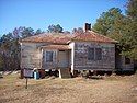
[Dates]: 1923 built2011 NRHP-listed
[Location]:
[City, State]: Westminster, South Carolina
[Description]: NRHP-listed -
[Name]: Allen-White School
[Image]:
[Dates]:
[Location]:
[City, State]: Whiteville, Tennessee
[Description]: NRHP-listed -
[Name]: Cairo Rosenwald School
[Image]:
[Dates]: 1922 built1996 NRHP-listed
[Location]: Zieglers Fort Rd., approximately 2.5 mi. S of TN 2536°21′48″N 86°21′49″W / 36.36333°N 86.36361°W / 36.36333; -86.36361 (Cairo Rosenwald School)
[City, State]: Cairo, Tennessee
[Description]: NRHP-listed -
[Name]: Free Hills Rosenwald School
[Image]:
[Dates]: 1929 built1996 NRHP-listed
[Location]: Free Hills Rd., E of TN 5236°33′49″N 85°29′23″W / 36.56361°N 85.48972°W / 36.56361; -85.48972 (Free Hills Rosenwald School)
[City, State]: Free Hill, Tennessee
[Description]: Free Hills Community Center in Free Hill, Tennessee. Free Hill is also known as Free Hills. -
[Name]: Lincoln School
[Image]:
[Dates]:
[Location]:
[City, State]: Pikeville, Tennessee
[Description]: -
[Name]: Pasquo School
[Image]:
[Dates]: 1927 built
[Location]: 8534 Lewis Road
[City, State]: Nashville, Tennessee
[Description]: As of 2018, a private residence -
[Name]: Hopewell School
[Image]:
[Dates]: 1922 built
[Location]: 690 State Highway 21 West30°05′55″N 97°27′40.5″W / 30.09861°N 97.461250°W / 30.09861; -97.461250 (Hopewell School)
[City, State]: Cedar Creek, Texas
[Description]: listed on the National Register of Historic Places in 2015 -
[Name]: Annie E. Colbert Rosenwald School
[Image]:
[Dates]: 1927 built
[Location]: 231 S Colbert Street30°02′46″N 94°52′45″W / 30.04611°N 94.87917°W / 30.04611; -94.87917 (Annie E. Colbert Rosenwald School)
[City, State]: Dayton, Texas
[Description]: -
[Name]: Pleasant Hill School
[Image]:
[Dates]: 1925 built2004 NRHP-listed
[Location]: 2722 Farm Rd. 139933°3′11″N 94°23′46″W / 33.05306°N 94.39611°W / 33.05306; -94.39611 (Pleasant Hill School (Linden, Texas))
[City, State]: Linden, Texas
[Description]: -
[Name]: Lockhart Vocational High School
[Image]:
[Dates]: 1923 built
[Location]: 1104 E. Market St.29°53′09″N 97°39′47″W / 29.88583°N 97.66306°W / 29.88583; -97.66306 (Lockhart Vocational High School)
[City, State]: Lockhart, Texas
[Description]: listed on the National Register of Historic Places in 1998 -
[Name]: Sweet Home Vocational and Agricultural High School
[Image]:
[Dates]: 1924 built
[Location]: 10 mi (16 km). S of Seguin on Sweet Home Rd.29°27′40″N 98°02′21″W / 29.46111°N 98.03917°W / 29.46111; -98.03917 (Sweet Home Vocational and Agricultural High School)
[City, State]: Seguin, Texas
[Description]: listed on the National Register of Historic Places in 1998 -
[Name]: Scrabble School
[Image]:
[Dates]: 1921-1922 built2007 NRHP-listed
[Location]: 111 Scrabble Rd.38°35′02″N 78°8′58″W / 38.58389°N 78.14944°W / 38.58389; -78.14944 (Second Union School)
[City, State]: Castleton, Virginia
[Description]: NRHP-listed -
[Name]: Second Union School
[Image]:
[Dates]: 1918 built2006 NRHP-listed
[Location]: 2787 Hadensville Fife Rd.37°45′52″N 78°3′10″W / 37.76444°N 78.05278°W / 37.76444; -78.05278 (Second Union School)
[City, State]: Goochland, Virginia
[Description]: NRHP-listed -
[Name]: East Suffolk Elementary School
[Image]:
[Dates]: 1926-1927 built2003 NRHP-listed
[Location]: 231 S. 7th St.36°43′30″N 76°33′51″W / 36.72500°N 76.56417°W / 36.72500; -76.56417 (East Suffolk Elementary School)
[City, State]: Suffolk, Virginia
[Description]: NRHP-listed -
[Name]: Nansemond County Training School
[Image]:
[Dates]: 1924 built2004 NRHP-listed
[Location]: 9307 Southwestern Blvd.36°38′22″N 76°48′16″W / 36.63944°N 76.80444°W / 36.63944; -76.80444 (Nansemond County Training School)
[City, State]: Suffolk, Virginia
[Description]: NRHP-listed
New Random Display Display All Items(82)