


-
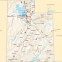
(#11) Utah
- 1896-01-04
The original Utah Territory was created in 1850 as part of the Compromise of 1850. Members of the Church of Jesus Christ of Latter-day Saints, led by Brigham Young, had already settled in the area, and proposed a state called "Deseret" that included parts of present-day Utah, Nevada, California, Arizona, New Mexico, Colorado, Wyoming, Idaho, and Oregon.
Congress didn't want to create such a large state, and limited the territory (which it called Utah) to about the same width as the proposed Deseret, from California to the Colorado Territory, but shorter in length, from the 37th parallel south to the 42nd parallel north. Pieces of the Utah Territory eventually went to Nevada on the west, Colorado on the east, and Wyoming and Idaho up north.
How did Utah, which became a state in 1896, get its L shape, created by its northeast border with Wyoming? According to Gary Alden Smith in State and National Boundaries of the United States, Congress wanted Wyoming to be a rectangular-shaped state, so it took that notch out of Utah. Also, the Uinta Mountains loosely form the right angle, so by taking the mountain portion, Wyoming would have guaranteed transportation access to Utah.
-
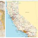
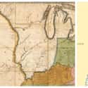
(#2) California
- 1850-09-09
A map of Texas, Oregon, and California by Samuel Augustus Mitchell, published right before the conflict between the United States and Mexico (1846 to 1848), refers to "Upper or New California," comprising the California of today along with "Old California" (now Baja California), and "the unexplored Region enclosed on the [west] by the Sierra Nevada and in the [east] by the Bear [River] and [Wasatch Mountains] ... called the Great Interior Basin of California." The Wasatch Mountains are in present-day Utah, so before California became a state, it covered a great deal more territory.
After the conflict with Mexico ended in 1848, the US acquired land that now includes present-day California, Nevada, Utah, Arizona, and parts of Wyoming, Colorado, and New Mexico. Although by then Congress was following a principle established by Thomas Jefferson that all states should be equal in size, California was huge in comparison to other states at the time.
Why did Congress create California as such a big state? According to Mark Stein in his book How the States Got Their Shapes, "It didn't: California created itself," or at least created its own boundaries. In 1849, just one year after the US acquired California from Mexico, gold was discovered, and people rushed to the area around the San Francisco Bay in search of their own fortune. When coming up with proposed borders, California wanted to keep all of the Sierra Nevada mountain range (where the gold was), and although Congress wasn't thrilled with that, members worried California would become its own nation, so they acquiesced. California also wanted to include all of what is now Southern California, even though the region was an arid desert, because San Diego's harbor farther south was a valuable resource.
According to Stein, "The United States needed California more than California needed the United States."
-
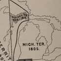
(#10) Michigan
- 1837-01-26
Michigan is more than just the familiar "mitt" shape - it also includes the unattached Upper Peninsula to the northwest that appears to be part of Wisconsin. Mark Stein, author of How the States Got Their Shapes, said in a Library of Congress webcast that the peninsula portion was a "consolation prize" to Michigan related to concerns about access to the Erie Canal (built from 1817 to 1825) from Michigan's southern neighbors in Indiana and Ohio.
Michigan became a state in 1837. In the early 1800s, when Michigan and Indiana were still just territories, the original proposal for Michigan's bottom boundary was along the southernmost part of Lake Michigan. But that gave Indiana too small of an access point to Lake Michigan and the future Erie Canal. Ohio, too, wanted more land to have access to a Toledo port. Congress gave those states what they wanted, and in turn handed Michigan the Upper Peninsula, which was in a territory few people lived in at the time.
-
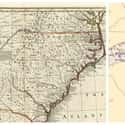
(#4) North Carolina
- 1789-11-21
A chain of errors by surveyors was responsible for the jagged border between North and South Carolina. In 1712, while still a colony, Carolina was divided into two parts. Charles Town (now Charleston, South Carolina), had been the seat of government for the colony, but when political factions formed there due to religious differences, England appointed a new governor in North Carolina.
The Carolina halves officially became separate royal colonies in 1719, which led to disputes over the border between them. A joint boundary commission decided the border should start south of the Cape Fear River northwest to the 35th parallel, then due west in a straight line, but errors by surveyors - their equipment was much less accurate then - and attempts to fix those errors, led to an almost comical series of mistakes.
At the time, North Carolina and other colonies also had boundaries they claimed stretched much farther west. To become a state in 1789, North Carolina agreed to surrender part of that western territory, including a portion that is now Tennessee.
-
(#6) Oregon
- 1859-02-14
By the late 1700s and early 1800s, Spain, Britain, Russia, and the United States had all claimed Oregon Country - comprising present-day Oregon, Washington, and British Columbia - as their territory. The US eventually acquired Spain's portion, and by the early 1840s, England and the US, which up until then had agreed to joint control of the region, decided to split up their territory.
The southern boundary of Oregon Country was set based on an agreement England made with Spain that placed the dividing line at 42 degrees north latitude (for complicated water-flow reasons). The US and Britain argued over the northern dividing line between Oregon Country and Canada, with England refusing to cede Vancouver. President James Polk, to avoid armed conflict, agreed to a compromise that was an extension of the eastern border at 49 degrees north latitude.
In 1853, the United States split what it now called the Oregon Territory to create the Washington Territory, which made the Columbia River the new northern border for Oregon. In 1859, when Oregon became a state, its eastern boundary was no longer the Rocky Mountains, but instead followed the Snake River south to its juncture with the Owyhee River, and then in a straight line south at the 117th meridian - selected because it would make both Oregon and Washington 7 degrees wide.
-
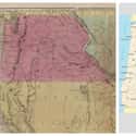
(#9) Indiana
- 1816-12-11
In 1804, Indiana was still a territory, and included what is today Illinois. Indiana was carved out of the Northwest Territory according to guidelines set out in the Northwest Ordinance of 1787; as the "middle" of three states, its southern boundary (the squiggly line still in place today) followed the Ohio River.
Before Indiana became a state in 1816, Congress further divided the Indiana Territory, creating Illinois. The southwestern border of Indiana followed the Wabash River north in a squiggly line, but then went straight up to Canada at a point north of the city of Vincennes, where the Wabash would be fully contained within Indiana.
New Random Displays Display All By Ranking
About This Tool
If you have checked the map of America, you will find that the borders between the US states, especially the western states, are straight lines, the shapes of many states are regular squares. However, these state boundaries are not drawn randomly on the map. Some state boundaries are due to natural factors, for example, the boundary between Oregon and California because of the direction of the river, some are related to history and culture.
After the states formally joined the United States, their sizes and shapes may have undergone tremendous changes. Here are some details about why these 13 US states that are different when they were proposed. It is a great time to learn more about US history.
Our data comes from Ranker, If you want to participate in the ranking of items displayed on this page, please click here.