


-
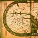
(#5) Anglo-Saxon World Map, Circa 1025-1050
The Anglo-Saxon map, made in Canterbury between 1025 and 1050, contains the earliest known realistic depiction of the British Isles. However, it is almost unrecognizable as a world map, in part because it doesn’t follow many of the conventions of other medieval T-O style maps. Like the Tabula Peutingeriana, it recalls a Roman past by using Roman names for the provinces.
The British Isles are at the bottom left corner of the map, with Jerusalem roughly at the center, again showing the influence of religion on medieval mapmaking. As with many medieval maps, the top is east. Before the 1500s, there was no convention about putting north at the top of maps, and many placed east at the top because Europeans were convinced the biblical Earthly Paradise was in the Far East.
-
(#12) Medici-Laurentian Atlas, 1351
Some medieval maps are still recognizable today. Africa might appear a bit strange on the Medici-Laurentian Atlas map from 1351, but Europe, North Africa, and the Middle East are all remarkably accurate. That’s because the anonymous maker of this map, probably from Genoa, was trained in making portolan charts.
Portolan charts were used by sailors to navigate the Mediterranean and Black Seas. They required precise geographic knowledge so ships would not get lost. While this expensive and beautifully painted map would not have been taken out to sea, it incorporates knowledge from portolan charts. It also serves as a reminder that religious medieval maps were not produced because mapmakers lacked geographical knowledge, but because the maps served a specific purpose.
-
(#7) Beatus Map, Circa 776
There are multiple versions of the so-called Beatus map, originally included in an 8th-century Commentary on the Apocalypse by Beatus of Liébana. Like the Psalter Map, versions of the Beatus map were included in religious texts in order to illuminate the study of religion.
The Earthly Paradise is shown at the top of the map, with Adam, Eve, and the serpent all making an appearance. But the map also includes fascinating decorative elements. The waters of the world are filled with fish and boats, and palaces also dot the land.
-
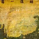
(#6) Da Ming Hunyi Tu Map, 1389
In China, medieval mapmakers produced the Da Ming Hunyi Tu, also known as the Composite Map of the Ming Empire, in 1389. The map, a full 15 feet wide, was painted on silk and showed the entire world as known to the Ming. It was also produced at a time of upheaval for China, when the Mongol Yuan rulers had only recently been expelled. In the late 1300s, China balanced between an international outlook, which had been promoted by Mongol rulers, and a more internal focus, promoted by more conservative factions.
Much of the knowledge in the Da Ming Hunyi Tu came from China’s many contacts with Muslim cartographers and intellectuals, and the place names on the western borders of the map are derived from Arabic names.
China would send out the voyager Zheng He to explore the world for nearly three decades in the early 1400s. But after his passing, Ming emperors decided to stop voyages of exploration and focus on China. As they argued, “barbarian” nations offered little of value to China’s prosperity.
-
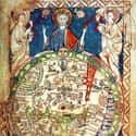
(#2) Psalter World Map, Circa 1265
Just in case the religious nature of the map isn’t clear, the Psalter Map, made in the 1260s, drives the point home by placing a giant image of Jesus on top. This small map, measuring only 6.6 inches high, was painted in a 13th-century copy of the Book of Psalms. In addition to Jesus holding court over the world, the Psalter Map places a large bull's-eye over Jerusalem at the center.
Mythical monstrous people inhabit the right side of the map, while the Red Sea is actually painted red. But these monsters are not just figments of the unknown mapmaker’s imagination: they are based on classical texts like Pliny the Elder’s Natural History. Pliny claimed a North African tribe was “said to have no heads, their mouths and eyes being seated in the breasts.” Here, Pliny’s classical tales mix with biblical knowledge on one map.
-
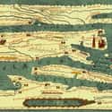
(#3) Tabula Peutingeriana, 1265
The Tabula Peutingeriana, an itinerary map, is a reproduction of a Roman map, showing the highways of the Roman world all the way from England to Sri Lanka. It isn’t to scale and manipulates space to show the road system. Pictured are stopping places, prominent towns, and mountain ranges.
The Tabula Peutingeriana is also massive at 22 feet in length. At that size, it wouldn’t be useful for a road trip, but with 555 cities and 3,500 place names, it is a chronicle of Rome’s reach.
The map’s geographic information dates back to before at least 79 AD, since you can spot Pompeii. The original map has been lost, but we still have a copy thanks to a monk who reproduced it on 11 scrolls in 1265.
New Random Displays Display All By Ranking
About This Tool
In the Middle Ages, people did not have map consciousness. As a new civilized world is being formed, the concept of maps that once existed in the Greco-Roman era is gradually dying out. Although some ancient Roman world maps were preserved until the early Middle Ages, they apparently disappeared as slowly as the dying classical traditions and knowledge, which also led to the production of strange maps at that time.
The knowledge and techniques of scientific mapping were not rediscovered until the 15th and 16th centuries. The random tool shows 12 weird maps of the Middle Ages that you must be interested in.
Our data comes from Ranker, If you want to participate in the ranking of items displayed on this page, please click here.