


-
[]: 12
[Name]: Sica Hollow
[Image]:
[Date]: 1967
[Location]: 45°44′31″N 97°14′33″W / 45.741944°N 97.2425°W / 45.741944; -97.2425 (Sica Hollow)
[County]: Marshall
[Ownership]: state
[Description]: Displays many facets of natural history. -
[]: 4
[Name]: Buffalo Slough
[Image]:
[Date]: 1980
[Location]: 43°52′28″N 96°56′20″W / 43.874308°N 96.939013°W / 43.874308; -96.939013 (Buffalo Slough)
[County]: Lake
[Ownership]: state
[Description]: Excellent examples of a prairie pothole with native emergent vegetation, and a native bluestem prairie. -
[]: 13
[Name]: Snake Butte
[Image]:
[Date]: 1967
[Location]:
[County]: Jackson
[Ownership]: tribal (Oglala Sioux)
[Description]: Illustrates one of two types of sand calcite deposits in the world. -
[]: 5
[Name]: The Castles
[Image]:
[Date]: 1976
[Location]: 45°31′39″N 103°10′15″W / 45.527583°N 103.170965°W / 45.527583; -103.170965 (The Castles)
[County]: Harding
[Ownership]: federal (Custer National Forest)
[Description]: Steep-walled, flat-topped buttes standing 200 to 400 feet (61 to 122 m) above the surrounding prairie. -
[]: 2
[Name]: Bear Butte
[Image]:
[Date]: 1965
[Location]: 44°28′33″N 103°25′37″W / 44.475833°N 103.426944°W / 44.475833; -103.426944 (Bear Butte)
[County]: Meade
[Ownership]: mixed- state, tribal, private
[Description]: A cone-shaped mass of igneous rock standing alone 1,300 feet (400 m) above the surrounding plains. -
[]: 6
[Name]: Cathedral Spires and Limber Pine Natural Area
[Image]: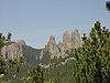
[Date]: 1976
[Location]: 43°50′28″N 103°32′40″W / 43.841111°N 103.544444°W / 43.841111; -103.544444 (Cathedral Spires and Limber Pine Natural Area)
[County]: Custer
[Ownership]: state (Custer State Park)
[Description]: An excellent, rare example of joint-controlled weathering of granite.
New Random Display Display All Items(13)