


-
[Name]: Deep Springs Marsh
[Image]:
[Date]: 1975
[Location]: 37°20′00″N 118°01′03″W / 37.33333°N 118.01750°W / 37.33333; -118.01750
[County]: Inyo
[Ownership]: Private
[Description]: An example of increasingly rare desert marsh. -
[Name]: Año Nuevo State Reserve
[Image]:
[Date]: 1980
[Location]: 37°7′7.24″N 122°18′24.02″W / 37.1186778°N 122.3066722°W / 37.1186778; -122.3066722
[County]: San Mateo
[Ownership]: State (California Department of Parks and Recreation)
[Description]: One of the largest mainland breeding grounds for the northern elephant seal. -
[Name]: Imperial Sand Hills
[Image]: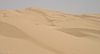
[Date]: 1966
[Location]: 32°55′0″N 115°3′0″W / 32.91667°N 115.05000°W / 32.91667; -115.05000
[County]: Imperial
[Ownership]: Federal (Bureau of Land Management)
[Description]: One of the largest dune patches in the United States. -
[Name]: Point Lobos
[Image]:
[Date]: 1967
[Location]: 36°31′1.56″N 121°56′33.36″W / 36.5171000°N 121.9426000°W / 36.5171000; -121.9426000
[County]: Monterey
[Ownership]: State (California Department of Parks and Recreation)
[Description]: An outstanding example of terrestrial and marine environments in close association, and the only known habitat of Monterey cypress and variegated brodiaea. -
[Name]: San Andreas Fault
[Image]: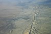
[Date]: 1965
[Location]:
[County]: San Benito
[Ownership]: Private
[Description]: One of the best illustrations of earth displacement caused by small crustal movements. -
[Name]: Sand Ridge Wildflower Preserve
[Image]:
[Date]: 1984
[Location]: 35°18′31.26″N 118°47′24.29″W / 35.3086833°N 118.7900806°W / 35.3086833; -118.7900806
[County]: Kern
[Ownership]: Private
[Description]: A remnant natural area displaying a great diversity of floral species including the Bakersfield cactus.
New Random Display Display All Items(36)