


-
[Marker title]: French Creek
[Image]:
[Date dedicated]: November 1, 1946
[Location]: US 19, slightly north of US 6, south of Waterford41°53′05″N 79°59′58″W / 41.88482°N 79.99943°W / 41.88482; -79.99943 (French Creek)
[Marker type]: Roadside
[Topics]: Early Settlement, Ethnic & Immigration, George Washington, Transportation
(Historical markers) -
[Marker title]: Cashier's House
[Image]: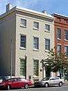
[Date dedicated]: 1980
[Location]: 417 State Street, Erie42°07′52″N 80°05′10″W / 42.131°N 80.0862°W / 42.131; -80.0862 (Cashier's House)
[Marker type]: Roadside
[Topics]: Buildings, Business & Industry, Houses & Homesteads
(Historical markers) -
[Marker title]: Otto Maya
[Image]:
[Date dedicated]: August 17, 2002
[Location]: 10th and State Streets, Erie (Missing)
[Marker type]: Roadside
[Topics]: Sports
(Historical markers) -
[Marker title]: Creation of the Pennsylvania Game Commission
[Image]:
[Date dedicated]: July 24, 2008
[Location]: Northwest corner of Corry City Park, at the intersection of North Center and Smith Streets
[Marker type]: Roadside
[Topics]: Environment, Government & Politics 20th Century
(Historical markers) -
[Marker title]: St. James A. M. E. Church
[Image]:
[Date dedicated]: 1994
[Location]: East 12th Street at Holland Street in Erie
[Marker type]: City
[Topics]: African American, Religion
(Historical markers) -
[Marker title]: Old State Line
[Image]:
[Date dedicated]: November 1, 1946
[Location]: West Lake Road at Happy Valley Road, Springfield Township41°59′59″N 80°24′20″W / 41.99983°N 80.40553°W / 41.99983; -80.40553 (Old State Line)
[Marker type]: Roadside
[Topics]: Government & Politics, Government & Politics 18th Century
(Historical markers)
New Random Display Display All Items(53)