


-
[]: 3
[Name]: Catfish Creek
[Image]:
[Date]: 1983
[Location]: 31°54′27″N 95°54′09″W / 31.90750°N 95.90250°W / 31.90750; -95.90250 (Catfish Creek)
[County]: Anderson
[Ownership]: state/Texas Department of Parks and Wildlife
[Description]: One of the few remaining undisturbed riparian habitats in the western Gulf Coastal Plain -
[]: 11
[Name]: High Plains Natural Area
[Image]:
[Date]: 1980
[Location]: 34°55′10″N 102°06′40″W / 34.919517°N 102.111118°W / 34.919517; -102.111118 (High Plains Natural Area)
[County]: Randall
[Ownership]: federal/US Fish & Wildlife Service
[Description]: One of the best developed, least disturbed natural shortgrass climax communities remaining in the Great Plains. Part of Buffalo Lake National Wildlife Refuge. -
[]: 15
[Name]: Muleshoe National Wildlife Refuge
[Image]:
[Date]: 1980
[Location]: 33°57′19″N 102°46′37″W / 33.955295°N 102.776973°W / 33.955295; -102.776973 (Muleshoe National Wildlife Refuge)
[County]: Bailey
[Ownership]: federal/US Fish & Wildlife Service
[Description]: Saline lake beds, and shortgrass grama grasslands characteristic of the high plains. -
[]: 7
[Name]: Ezell's Cave
[Image]:
[Date]: 1971
[Location]:
[County]: Hays
[Ownership]: private
[Description]: Houses at least 36 species of cave fauna. -
[]: 19
[Name]: Natural Bridge Caverns
[Image]: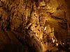
[Date]: 1971
[Location]: 29°41′32″N 98°20′34″W / 29.692351°N 98.342760°W / 29.692351; -98.342760 (Natural Bridge Caverns)
[County]: Comal
[Ownership]: private
[Description]: A multilevel cavern system containing unusual speleothems and intricate helictites. -
[]: 20
[Name]: Cave Without a Name
[Image]:
[Date]: 2009
[Location]: 29°52′45″N 98°38′31″W / 29.8791769°N 98.6419260°W / 29.8791769; -98.6419260 (Cave Without a Name)
[County]: Kendall
[Ownership]: private
[Description]: Contains rare and nationally outstanding examples of speleothems.
New Random Display Display All Items(20)